Wednesday, December 14, 2022

Adaptive Reuse in Carlisle, North Middlesex


The Presbyterian Church Heritage Centre (PCHC) is moving into Carlisle United Church, in the hamlet of Carlisle, near Ailsa Craig in Middlesex County.*

Formerly the National Presbyterian Museum, the PCHC was located in St. John's Presbyterian, Toronto, from 2002 to 2021. But that church is currently being renovated into condominiums, forcing the Heritage Centre to find a new home. The new location will be this quaint country church built in 1879. 

Like many congregations, the Carlisle church started out in an earlier building. Carlisle Presbyterian Church was founded in 1858 in a more primitive structure, replaced as soon as funds became available. The congregation joined the United Church of Canada in 1925.

But recently, like many rural congregations in the 21st century, Carlisle United has been struggling. With 19 members left in the congregation, continued use of the building was becoming impossible. Having the PCHC move in has brought new life to these folks, even though they've had to worship in the church basement. The former upstairs sanctuary will be renovated into an exhibit hall. 

Temporary basement sanctuary

The move of the PCHC hasn't been easy or cheap. A fundraising campaign was necessary to increase the load-bearing capacity of the Carlisle church's sanctuary floor from 40 lbs. per sq. ft. to 100 lbs. per sq. ft. This involved removing the ceiling in the downstairs hall so the contractors could add the necessary reinforcement joists. But the pandemic allowed the necessary work to proceed easily, since there was no weekly worship service. 

The renovated building will include a replica chapel of the 1850s, an enlarged version of what was in the earlier museum in Toronto. Accommodating about 30 people, the replica can be used by the Carlisle congregation and for occasional weddings. The only condition is that, when visitors tour, it will be necessary to hide the church's large electronic organ. After all, no instrument of any kind was present in the strict services of yesteryear. So the plans will have to include a method of disguising that organ.

Additionally, thanks to the PCHC moving in, the church building will have a few mod cons it's never had before: air conditioning, a security system, and a phone, for the first time in its 164 year history!

Pews are currently stored in the future site of a replica pioneer sanctuary. 

Magnificent memorial windows in what will become the upstairs exhibit hall. 


The PCHC is not scheduled to open until 2024. But I have a question already. Where will visitors stay overnight or eat? Carlisle is a bit off the beaten track.  

Victoria Inn. Note Middlesex Heritage Trail sign out front. 


What I'd like to see is the old Victoria Inn, also in Carlisle, become a B&B to accommodate visitors to the PCHC. Built in 1855 by Joseph and William Haskett, this example of an early Ontario inn once featured a verandah across the front, complete with hitching posts for horses. The building has never had running water, central heating, hydro, or phone. A building more authentic than this you simply can't get. 

New owners are renovating the interior. ( I don't encourage trespassing but when a building is this close to the road it's hard to resist peaking through the windows.) I haven't heard they're planning a B&B. They probably aren't. But I can't help thinking what a fine heritage inn this would make. 

Who knows? With enough attractions this "ghost town" might be back on the map. Carlisle was one of the most important villages in north Middlesex in pioneer days, with a population of 200 or more. Settler George Shipley of Carlisle, England, named it after his home town. Building a dam across nearby Linn Creek, Shipley soon constructed a flour mill and other businesses were quick to follow. When a post office opened in 1853, it had to be named Falkirk, there being a Carlisle elsewhere already. Old maps use either name, depending on the mapmaker's point of view. The village declined after the railroads - both the Grand Trunk and the London, Huron & Bruce - bypassed it. Today, the community is mainly residential and very quiet. A good place for an afternoon drive to "get away from it all." 

* A big thank you to Curator Ian Mason for information and to local resident Doug Carmichael, member of the Advisory Committee for the PCHC, for the tour of the church interior. 


Update, December 19: Latest word is that the PCHC has received a $100,000 grant from The Presbyterian Church in Canada to finish the project. 

Tuesday, October 4, 2022

Day Trips: Port Burwell


Not everyone thinks of Port Burwell when choosing an interesting day trip. But not only does this Lake Erie village have a nice, sandy stretch of beach, it also has history. Which is why a friend and I made the trip from London this summer. 

First, why is it called Port Burwell? Because Col. Mahlon Burwell (1783-1846) surveyed the land here, completing the job in 1810-11. While dividing Bayham and Malahide townships into lots for settlers, he selected a block of land in Bayham for himself at the site that is now the village. Eventually, about 1830, he surveyed his plot into streets and building lots as well. He likely recognized that the nearby Big Otter Creek and harbour would provide a useful water route for landlocked communities to the north. In time, Port Burwell became a shipbuilding and fishing harbour and an export point for lumber and farm produce from surrounding townships. It wasn't really until the 1920s, in a more leisurely age, that the port became a summertime tourist destination, known for its beach. 

Burwell family graves at Trinity Anglican.
Members of the Burwell family continued to live here after Mahlon's death, his son Leonidas (1818-79) taking over the family interests in 1842 and making the village his home. Many family graves can be found at historic Trinity Anglican Church, built in the village in 1836 and still standing today. However, Mahlon and his wife Sarah are buried at Burwell's Corners, Dunwich Township (Fingal Line and Iona Road). 

The church itself, at Strachan and Pitt streets, is a simple early Gothic Revival building, paid for with financial assistance from Mahlon himself. Strachan Street would be named after The Venerable John Strachan, Archdeacon of York, who preached the first sermon at Trinity. 

The village is also the location of the Port Burwell Marine Museum and Historic Lighthouse. The museum pays tribute to the village's history as a shipbuilding centre. A better than average community museum, it's filled with artifacts from Lake Erie shipwrecks, as well as anchors, foghorns, and other nautical stuff. There's even the wheelhouse from a Great Lakes freighter. 

The Port Burwell Historic Lighthouse is across the street from the museum. Completed in 1840 and restored by Mennonite craftsmen in 1986, it is now one of Canada's oldest lighthouses of completely wooden construction. I'm unclear on how much of the original wood had to be replaced in the restoration, but it still looks authentic. The 45 foot high octagonal structure was deactivated in 1963 but if you're energetic you can still climb 56 steep steps to experience the view from the top. (I didn't, being out of shape.)

Recently I heard a rumour that the Municipality of Bayham was planning alterations to the lighthouse in another upcoming restoration. Word on the street was that the clapboard would be replaced with Hardie cement board and the wooden door with fiberglass. However, reaching out to Bayham Municipal Council for more information, I was told that staff will be consulting architects qualified in historical structures to identify appropriate options. 

[Update: April 2023: Bayham Township is undertaking a stabilization and restoration project on the lighthouse. Much needed since the road to the beach had to be closed in recent months, just in case the structure toppled over in high winds. Work is being conducted by Heritage Restoration Inc. of Stouffville.]

Port Burwell's other nautical exhibit is the HMCS Ojibwa, a retired Canadian Navy Cold War submarine moved here in November 2012. The sub has nothing to do with the lake port, of course, but organizers hoped it would complement the marine museum and lighthouse. Villagers may have hoped that droves of tourists would arrive to tour the sub and, while there, would eat at a village restaurant, buy ice cream, shop, attend the local theatre ... you get the picture. I'm not sure if the dreamed-of crowds actually came but the Ojibwa is still there, open during summer for tours, so tour it we did.  I'm sorry it took me so many years to get around to it. 

HMCS Ojibwa
Ian, our tour guide, and the man responsible for relocating the sub to Port Burwell, is well qualified to explain the technical aspects of this vessel that served from 1965 to 1998. He also explained its human side, what it was like living on board with 60 other crew members. I expected to feel claustrophobic and was pleased to discover I wasn't. But then, it was just the two of us plus our guide. Hats off to those who could live in such close quarters with dozens of shipmates for weeks at a time without losing their minds! And if you think you're not interested in the military, you might be surprised how much you'll learn that's of interest. My respect for the Navy increased and it wasn't too shabby to begin with. 

Elgin County Tourism calls Port Burwell the "Jewel of Erie's North Shore" that "really knows how to live it up!" This is propaganda, of course; even Port Stanley is more exciting. Still, our small towns and villages need all the support they can get. Port Burwell deserves more than just an A for Effort. Its attractions are worth seeing. Visit Mahlon's place when you get a chance. 

Port Burwell postcard, dated 1909 by a former owner (The blogger's collection).


Sunday, October 2, 2022

The Most Haunting of Former Villages

Southwold Earthworks, site of an Attawandaron village ca. AD 1450-1550.

One of the eeriest places in Elgin County is the so-called Southwold Earthworks, the remains of a fortified Attawandaron* village of about 800 or 900 people inhabited ca. 1450 to 1550. Located at 7930 Iona Road near Fingal, the spot has been a National Historic Site since 1923. 

The Attawandaron, an Iroquoian-speaking people French explorers called the Neutrals, built a cluster of 18 or more longhouses here of various sizes. The longhouses were multi-unit dwellings housing extended families related by a common maternal ancestor. Archaeologists have determined this in two excavations, the first in 1935 and the second, more scientific investigation, in 1976. The latter dig was performed by London's Museum of Indian Archaeology as the Museum of Ontario Archaeology was then called.

The village was surrounded by a double row of low earth mounds, foundations for a double ring of upright pickets or palisades. The first palisade might have been built earlier, the site being strengthened by a second wall for improved defenses later. 

It's unusual for an Attawandaron village to be located on a flat plain with no defensive advantages. There's also no archaeological evidence that the site was ever attacked. Tradition within the local Oneida community suggests that this was really a ceremonial site, only enclosed by a palisade so that activities taking place in the village would not be visible to people outside. The site might have been a seasonal place of pilgrimage, not a year-round village.

My thoughts: 1) Just because there was no attack does not mean the inhabitants did not live in fear of one. 2) A double palisade seems like overkill for a ceremonial site. 3) Some members of the Indigenous community may prefer to interpret their ancestors' behaviour as uniformly peaceful and spiritual, instead of warlike and aggressive. Despite opinions to the contrary, I still suspect the inhabitants of this village lived in fear of their neighbours. 

Regardless of the site's controversy, it's still a nice place to take a picnic and walk your dog. There are also several interpretive plaques describing the lifeways of the long-ago inhabitants. There's no admission charge since it's basically a park. But bear in  mind the Earthworks are a long walk from the road, so this isn't a site for the physically challenged. And it might be a bit creepy if you're alone. 

It's also not a site for people who can't picture in their minds the sizable village that once stood here. It's an archaeological site, folks. If you wish to see an actual recreation of a village, visit Ska-Nah-Doht or the Museum of Ontario Archaeology

But if you have a powerful imagination and you close your eyes in this quiet spot, you can easily visualize the men, women, and children who worked and played in the longhouses.  

* I've chosen to spell the word like Attawandron Road, location of London, Ontario's Museum of Ontario Archaeology. You may also see it spelled Attiwandaron, Attiwandaronk, and Attarawandon. 

Military Site Returns to Nature

In September a friend and I visited the site of the British Commonwealth Air Training Plan's No. 4 Bombing & Gunnery School, near Fingal, Elgin County. No. 4 BGS was operated by the RCAF from November 25, 1940 to February 17, 1945. Over 4,000 aircrew from Canada, Britain, New Zealand, and Australia graduated from No. 4 BGS as well as another 2,000 aircrew from other countries, such as the US, Norway and France. Except for Air Gunners, all other aircrew trades received initial advanced training elsewhere and finished their training at bombing and gunnery schools. Air Gunners received all their advanced training at these schools. The RCAF continued operations at this particular site under a number of names until closure in 1961 when the Province of Ontario took over the property. 

Site of former hangars. 
The area is now the Fingal Wildlife Management Area, managed by the Ministry of Natural Resources and Elgin  County Stewardship Council. Nature is busily reclaiming the property, helped by plantings of trees and shrubs. Trails now cover the site of the six steel-framed hangars, large drill hall, and 50 other buildings, including canteens, repair shops, recreational facilities, and three hard-surfaced runways. A series of ponds have been developed and photographic signage added to show visitors what buildings stood where. A trail guide with colour map is available, listing walking trails and common trees. 

My friend brought along an older leaflet identifying the locations of various buildings, far more useful if one's interest in the site is historical, not arboreal. Not sure if that booklet is still available to the public. 

 
Walking trails show traces of former pavement.
 The majority of visitors may be walking dogs, bird     watching, or even hunting on designated days in the   southern section of the property. Still, for those   interested in military history - or any history - the site is an interesting tribute to the men and women who lived and worked there in the '40s. 

 I have to say the site deserves a little more   maintenance. Some interpretive signs are becoming   hard to read and foliage needs cutting back so they can  be read more easily. For example, a memorial plaque  was erected in 1993 in memory of the RCAF personnel   who served here (see top left). The reverse side lists  casualties, those who died on duty at No. 4, mainly in  training accidents. It's a little hard to read at the  moment, since a nearby bush is taking over. The text of  the plaque is listed here.

 When the generation who served in the war - or even   remember it as children - are gone, will this site be   preserved? With a possible recession looming on our   horizon, will funding be available for replacement signs? Or will this site literally go to the dogs?


An interesting sign on one of the walking trails in need of cleaning or possible replacement. 

Ian Carmichael Pond photographed from nearby viewing stand.


Remains of incinerators where military documents were burned. 


Thursday, September 22, 2022

Tombstone Tourism: North Nissouri United Church

One of the most scenic locations in Middlesex is at 24058 Fairview Road, north of Cherry Grove in the former West Nissouri Township, part of Thames Centre since 2001. The spot is North Nissouri United Church and its surrounding cemetery. 

First of all, let's establish what "Nissouri" means. Some residents believe it's a corruption of the phrase "nigh Zorra," meaning "next to Zorra." Why? Because East Nissouri Township in Oxford County was situated next to Zorra Township.* Forget it. Nissouri means something like "gurgling waters" in an Indigenous language. When the former township was first settled by Europeans, there were many running streams emptying into the nearby Thames. 

Land for this church and cemetery was donated by George Black in 1844, a decade before the church was built. The church was constructed from heavy oak timbers supplied by local farms and has rounded windows. It was veneered with brick in the 1880s by John Thompson. The first minister was Robert Hall who served for twenty-one years as a circuit preacher in the neighbourhood. By the 1860s, there was a forty-member congregation. 

Cement block Sunday School room at rear.

Originally Presbyterian, the church joined the United Church of Canada in 1925 after church members voted in favour of church union. The church was lit by coal and Coleman lamps before hydro was installed in 1938. A drive shed once to the north of the building is now gone. 

The congregation celebrated its 150th anniversary in 2004 but disbanded in the summer of 2021. One assumes attendance had dropped to far fewer than forty. No word yet on what happens to the building now.

But the church is perched on a hill surrounded by a cemetery of one and three quarter acres overlooking Gregory Creek valley. Now inactive, the cemetery is said to have more than 800 burials, the first known interment being that of Hannah Horton, local midwife, in 1844. I didn't find a grave marker with her name but there can be no doubt there are many more graves than gravestones. This is true of most older cemeteries. Many families could not afford a marker and some markers have been lost. 


The gently-sloping graveyard reminds me of the macabre poem "The Coffins" by southwestern Ontario poet James Reaney (1926-2008): 

These coffins are submarines
That will sail beneath the slopes 
Of grey-green old graveyards.
One white lone sailor to each
Submarine that navigates 
The wormy seas of earth.
With shrouds for uniforms
Stitched by weeping tailors
These bony sailors
Shall sail deep field and morass
Without periscope or compass
They'll only dimly know
That someday they must flow
Into the final harbour
On some high gray shore
Where the Lord shall weigh
Men's wicked souls on Doomsday.**

A poignant reminder of the harshness of pioneer life:
"To The Memory of George McDonald Who died Sept. 4th 1852 Aged 35 Years. And His Wife Mary, Who died Sept. 21, 1853 Ae. 24 yrs." 

*East Nissouri, West Zorra, and North Oxford townships were amalgamated into  a new township called Zorra in 1975.

**James Reaney, The Red Heart. Toronto: McClelland & Stewart, 1949. p. 60.

Sunday, September 18, 2022

Milling Around: Arva Flour Mills


This summer a friend and I were fortunate enough to get a rare behind-the-scenes tour of Arva Flour Mills from its new owner. I say fortunate because it's not everyone who's had a chance to view the antique milling equipment inside this pioneer building on the banks of Medway Creek. I say rare, because most visitors only see the workings through a door while shopping in the attached store. But I have friends in high places: my travelling companion once worked with owner Mark Rinker's dad, Fred. They got chatting, and the rest is history. 

Mark, who purchased the business from Mike Matthews in 2021, has done his research and believes the mill, established in 1819, is Canada's sixth-oldest continuously operating business. And perhaps the oldest food-producing company in Canada too. Most historians agree that Arva Flour Mills is North America's oldest continuously-operating, water-powered commercial flour mill. 

Pioneer tool marks on an interior beam.
The business was founded when much of the surrounding area was forest and nearby Richmond Street, then known as the Proof Line, was the main route north through London Township. In the 1800s, the owner often allowed customers to barter for flour, accepting items like turnips or boots as payment. 

In early twentieth century, the original grist millstones were replaced with roller mills made by Goldie and McCulloch of Galt (now Cambridge), state-of-the-art technology for the era. At the same time, an outside water wheel was changed to an underwater turbine. For the most part, the mill operates the same way as it did in the early 1900s, half run by water power, the rest by electricity. 

The equipment allowed the mill to produce 30,000 pounds of flour a day, much of which was purchased by McCormick's in London. With little competition and a major company as a customer, there was probably little need to update equipment, which is why the mill is a rare operating antique in the twenty-first century. 

While there have been many owners over the years, the family of Mike Matthews operated the mill for over four generations since 1919. That must be some kind of flour mill record. 

As I mentioned in a previous post on mills, Arva Flour Mills was shut down by a federal safety inspector in 2017. The inspector was concerned that the old equipment, with its exposed rollers and belts, was a hazard for workers. This despite the fact that Mike and his workers were highly trained on the use of their machinery. Fortunately, common sense prevailed and a federal tribunal later overturned the ruling. The mill was allowed to operate again on the understanding that no workers, not even the owner, are allowed in the upper level of the mill when the equipment is running. Fair enough.

Mark Rinker shows off his equipment.

 Using wheat from local farms, the old roller mills  produce a     "heritage flour" with no preservatives or undesirable     commercial  additives. The store sells flours, mixes for beer   bread and cornbread, and red fife pancake mix as part of the   Arva Flour Mills brand. Mark also bought the Red River Cereal   brand from Smuckers Foods of Canada which had stopped   selling the brand last year. Created in Manitoba in 1924, the   cereal was named after the Red River near Winnipeg. The   recipe  included cracked wheat and rye but was altered about   ten  years ago to include steel-cut wheat instead. Mark's historic   business is now producing the original recipe on site. The cereal   is now available at the mill store and beyond. 

 For such an old business to be booming is fabulous for Mark     and  his family but also for the community of Arva, the wider   London region, and heritage preservationists. The mill's   continued success under sympathetic, enthusiastic management   proves that not everything old needs to be demolished. 

Arva Flour Mills remains a significant and valuable Southwestern Ontario landmark. 


Thursday, July 14, 2022

History Murals of Southwestern Ontario

I'm always looking for something positive to report on Southwestern Ontario's historical scene. Often months go by. But this summer's day trips have provided me with lots of visual reminders of our local history in the form of colourful murals. Not only am I enjoying them, I'm starting to go out of my way to see them. 

I figure these murals are great in lots of ways: they provide work for artists; they celebrate our region's unique heritage and character; they help revitalize struggling small towns by providing energy and interest; heck, they may even bring in a few tourist dollars. 

Most of them are painted in the artist's studio on panels and then assembled on site. This means that a mural can be taken down, repaired, if necessary, and remounted later, even in a different location. Occasionally, though, there's one painted directly on a building wall. 

Of course not all murals feature local history. But this is a history blog so this is what you get:

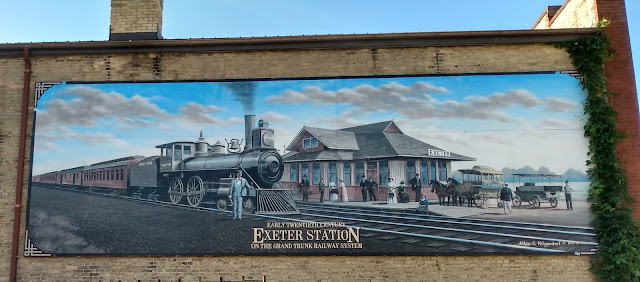
On the side of a building in downtown Exeter, facing a parkette, this mural by Allen C. Hilgendorf features the town's Grand Trunk Railway station.

Ruth Hurdle's portrayal of early Parkhill brightens the side of an older village building.


This mural at 172 Main Street, Ailsa Craig, shows five buildings from the town's past as well as portraits of the village founders. 


What better way to brighten a boring bank? Mural in Lucan by A. R. Gillett, 2019.


This memory of the 1925 Clinton Old Boys' Reunion, complete with photo corners, greatly improves an ugly building next to a town parking lot.

Another Clinton mural highlights the town's spring fair. 


Once again, a bank sponsors mural art, this time featuring historic headlines in Seaforth. Note the historic post office building in the background where the clock tower even showed the right time.

A mural in Port Burwell highlights the harbour in busier times. Painted in 2000 by Rick Johnston, it now has a little wear. 

St. Thomas is leading the way in Southwestern Ontario with murals galore:

This cheerful sign brightens up an ugly wall.


Many of St. Thomas's murals feature the city's railroad history. 

Ditto.

One side of a long mural paying tribute to members of the Elgin Regiment 91st Battalion, shown here departing for the Great War. 

Continuation of the above. Painted by "Rik" in 1996.


A nice tribute to the area's agricultural heritage on the Locke Insurance building. Unfortunately, the descriptive wording in the bottom right corner is defaced. 

This colourful display pays tribute to many features of St. Thomas heritage, including Jumbo.

Some old rail cars are also painted. 

These are photos, not murals, but they add to the fun. Mounted on the side of the Elgin County Railway Museum. There's lots more on another side. 


OK, London's not a small town, but we do have:

A newish mural of the Old Courthouse on the side of DeMelo Law, 239 Colborne Street, London.
What a nice touch. 

Got a blank wall? Hire an artist! I'll be adding more as I prowl. 

Murals Continued 2023:

Summertime '59 (Port Dover) by Michael Swanson. This artist's clients include Wayne Gretzky, Tim Horton's, and Dave Thomas of Wendy's restaurants. The mural in Port Dover is now a bit faded.

A small mural on the side of an empty store in Bothwell, Chatham-Kent.

Mural on the side of Waterford Heritage Museum, Norfolk County, accompanied by display of agricultural equipment. Painted by Jason Kirby and Kevin Judd, the mural shows the town in 1890.  


A bit of everything - including Paul Henderson - on this Lucknow mural. (Courtesy of Ernie Wright.)


Added recently to London's Budweiser Centre is Kevin Ledo's huge mural of the historic moment on February 22, 1968 when Johnny Cash proposed to co-star June Carter on stage. Of course, that happened at London Gardens on the east side of Wellington Road, south of Hwy. And, it would be nice to have more Canadians commemorated in London. But I'll take whatever history we can get.