Normally, if you want to see the pioneer buildings constructed by our ancestors, you have to visit a museum like Fanshawe Pioneer Village. That's because most of our early buildings were torn down and replaced with larger, grander ones as soon as it was practical to do so. If not demolished, the earliest buildings were usually modernized to include electricity, plumbing, openable windows, and insulation. Nobody likes privations.
That's why it's fascinating to enter one of those rare pioneer structures that's almost completely unchanged. I'm talking about St. Mary's, Napier.
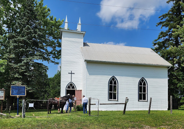 |
| St. Mary's Anglican Church, Napier, southwest of Strathroy in the Township of Adelaide-Metcalfe, held its Annual Decoration Day service on Sunday, June 22, 2025. Fred Cahill, who lives down the road, rode his horse, Beauty, to the event. She was a reminder of those long-ago days when most of the congregation arrived by horse and buggy. |
This unassuming little frame building was built in about 1841 in the village of Napier in what was, in those days, Metcalfe Township. Centre of a thriving community founded by retired veterans of the British Army and Navy, the church remained open for weekly services until about 1920. Then, with a dwindling congregation, the church closed. Instead of being demolished, though, it became a Chapel of Ease, still used for occasional services like the one I attended with about 30 other people (and Beauty, the horse) last Sunday.
No, my ancestors didn't live nearby, they didn't worship here, and I don't have relatives buried in the adjoining graveyard. So why attend? Because St. Mary's is now the oldest remaining church in Middlesex County and a treat for history buffs.
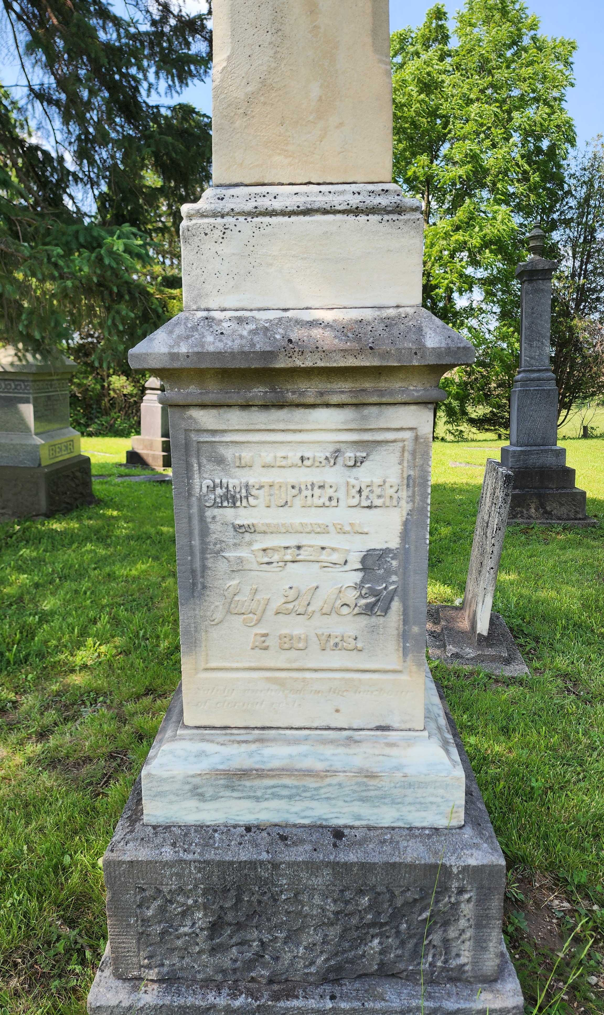
The story inside the service booklet states that early settler Captain Christopher Beer (gravemarker at right) was about to build himself a new house out of the local black walnut. But when he heard a church was to be constructed, he put off the building of his own home and donated the lumber to the church project instead. The walnut was used to build the chancel, pulpit, pews, and wainscotting. It's still in there today, dark and handsome as ever.
There was more to the building project than Captain Beer, of course. The land for the church and cemetery was donated by Lieutenant Charles Preston. The Phillips family donated the oak stringers and some bricks came from Captain Johnson's brickyard. That was how a pioneer community worked; everyone pitched in what they had, whether it was time, labour, materials, or funding.
At one time, services were so popular that a gallery was installed to accommodate everyone. But by 1895, the gallery was deemed unsafe and the congregation was too small by then to warrant it anyway. It was removed.
Let's step inside and see what it's like today:
 |
| "Box pews" with doors, designed to provide warmth and privacy. Such doors were common before churches were heated, allowing seating areas to retain warmth, either from bodies sitting close together or from foot warmers. When pews were owned or rented, such doors helped ensure that everyone sat in the correct place. |
 |
| Fresh flowers for the Decoration Day service. Note the walnut pulpit. |
 |
| Storage. |
 |
| View from the pulpit. |
 |
| Pump organ added in the 1900s has not worked for 20 years. (I heard a rumour about mice.) |
 |
| Close-up of the foot pedals reading "Doherty Organ." For a history of Doherty, see here. |
 |
| I wonder who was small enough to sit on the back row pews? Were Victorian bums this much smaller than ours? Or did children sit here? |
 |
| Photos and documents hang on the wall. Here's a photo of those in attendance on June 30, 1963 when the blue plaque from the Archaeological and Historic Sites Board of Ontario was placed out front. One of the gents is a great-grandson of Captain Beer. |
By the way, while sitting through the half hour service presided over by Rev. Patty Dobbs Luxton of Strathroy, I became aware of the extent to which our pioneer ancestors were at the mercy of the elements. It was over 30 degrees on Sunday and this little building has only one door, early unopenable windows, and no electricity. So no air conditioning and not even a cross breeze. The heat you can't imagine. Every time I stood up, my dress stuck to the rear of the pew. Just imagine sitting there in long sleeves, multiple petticoats and a bonnet. Egad.
Next, think about winter. No electric heat. No insulation of the modern variety. (Could there be horse hair in those walls?) No storm windows. And I'm not sure if there was ever a wood stove. The congregation might have seen the officiant's breath in the air. Huddle with your neighbours to keep warm.
Back outside, I trotted around the graveyard. Since I first visited St. Mary's back in the 1990s, the stones have greatly deteriorated. Aside from the monument to Captain Beer (now "Anchored in the harbour of eternal rest") the others are mainly illegible:
Some TLC is obviously needed. But I'm sure that diocese funds are woefully inadequate. What's required is a fundraising organization. Would someone like to start "The Friends of St. Mary's, Napier?" I'll join.
You may be wondering why this little church closed. That's easy. It's in a ghost town. Napier, on the Sydenham River, was once one of the most important villages in west Middlesex. It was a milling village, built to take advantage of the walnut trees in the vicinity. Once the walnut trees were depleted, there was obviously less work for the sawmills.
But in 1857, according to Lovell's Canada Directory, Napier also had a gristmill, woollen mill, school, store, blacksmith, shoemaker, waggon maker, saloon, and many homes. By 1864, there were two hotels, the Napier Inn and the Sydenham House, and a population of about 250. A post office named Napier opened on November 6, 1851, under postmaster James Keefer, who was running a store with Captain John Arthur. Mail came by stagecoach.
In all probability, Napier faded after being bypassed by the railroads. Both branches of the Great Western Railway, later the Grand Trunk or CNR, were built elsewhere, the north branch through Kerwood and the southern through Glencoe. Later the village was bypassed by the CPR and the Michigan Central. The community just couldn't win. The post office closed in 1915.
Recently there was an attempt to restore one of Napier's old buildings, the 1872 Napier House store. The effort failed and it now looks like this:
Apparently a saviour is needed here too.
A greater puzzle, as far as I'm concerned, is why St. Marys was preserved after closing. In 1939, it was in poor repair, turrets fallen off the tower, windows broken, and the graveyard thick with weeds. It was restored, when and by whom I'm not sure. But with no regular congregation, there was no need for updates. It seems that enough people cared about St. Mary's to preserve it, even if it remained a primitive pioneer structure.
I hope it remains for many years to come.